Support
Davy
(Customer support)
Tawin
(Handling complaints)
>800 million
of products on Amazon
200.000 successful
transaction through Fado168
0885996168 086356168
0

RTK GNSS Survey Equipment 60° Tilt Built-in IMU,Equipped with Rover Handheld GPS for Surveying and Survey Software Ideal for Land Surveying,GIS,Mine Surveying,Topographic Survey

0885996168

Monday to Friday: from 08h - 22h, including Saturday and Sunday

$1,553.26

Delivery time 15-20 day. View detail
The Product does not have an exact weight, The total order value may be changed after approval
Style:
Quantity:
Seller List
The Time commitment
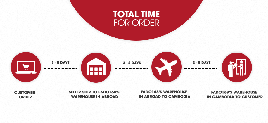
Fado168.com offers flexible shipping packages
3-5 days 7-20 days
+ See the detail
Free customs procedures
Fado168.com represent the customers to handle all the paperworks from the stage of export from ASIA import to Cambodia
+ See the detail
Diversified payment, flexible
Transfer by Internet Banking, via Bank account, by Wing or pay direct at Company
+ See the detail
Free delivery
Free delivery in Phnom Penh
+ See the detail
Safe shopping
With Fado168.com buyers always have insurance the risk when order the international goods
+ See the detail
Loading Product Infomation...


PRODUCT FEATURES
  • 【Why Choose Sfaira ONE Plus?】Our gnss rtk is Up to 60° tilt surveying, pocket-size portability, and a 16-hour battery. Sfaira ONE Plus tracks GPS, BDS, GLONASS, Galileo, and QZSS for a professional and efficient surveying experience.
  • 【Wide Applications】The accurate coordinates, elevation, distance and azimuth data measured by rtk gps Sfaira ONE Plus can be used in land surveying, GIS, mine surveying, topographic survey, cadastral survey, road stakeout, robotics, etc.
  • 【How to use?】 ① Connect the Sfaira ONE Plus with your phone via Bluetooth. ② Login to your CORS account (RTK corrections service) in the software or connect to your RTK base station of internal GSM mode and get fixed RTK solution. ③ Initialize the tilt IMU function - shake the pole for 5 seconds. ④ Start working: the software supports Point Survey, Detail Survey, CAD Mapping, CAD stakeout, Road Stakeout, Surface Stakeout, Layer Editting and wide calculation functions.
  • 【Software Free Upgrade】The android-based field surveying software can be installed on your smart phones, data collectors and tablets. The latest upgraded software version is always available for every user.
  • 【Easy to get started】Tutorial videos, detailed manual and online one-to-one technical support can definitely help every user to get started with gnss surveying equipment Sfaira ONE Plus easily without concerns.
  • 【Support】Please refer to the manual included in the package, email us for technical support, or visit the SingularXYZ website to get in touch. We also offer video conference guidance of our gps rtk to assist you.
Contact