Support
Davy
(Customer support)
Tawin
(Handling complaints)
>800 million
of products on Amazon
200.000 successful
transaction through Fado168
0885996168 086356168
0

Surveying Equipment, NOAA Certificated SMA26 GNSS IMU RTK GPS Rover Base Handheld Collector with Survey Software, Max10km and 0.5cm Accuracy,32G Storage (Exclude Tripod&Pole)

0885996168

Monday to Friday: from 08h - 22h, including Saturday and Sunday

$2,272.66

Delivery time 15-20 day. View detail
The Product does not have an exact weight, The total order value may be changed after approval
Style:
Quantity:
Seller List
The Time commitment
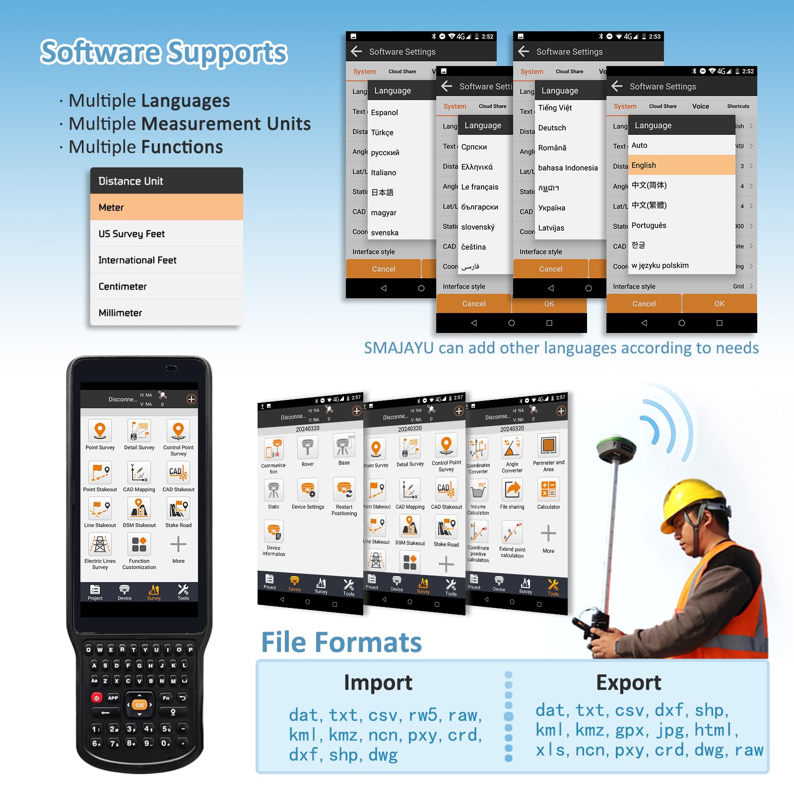
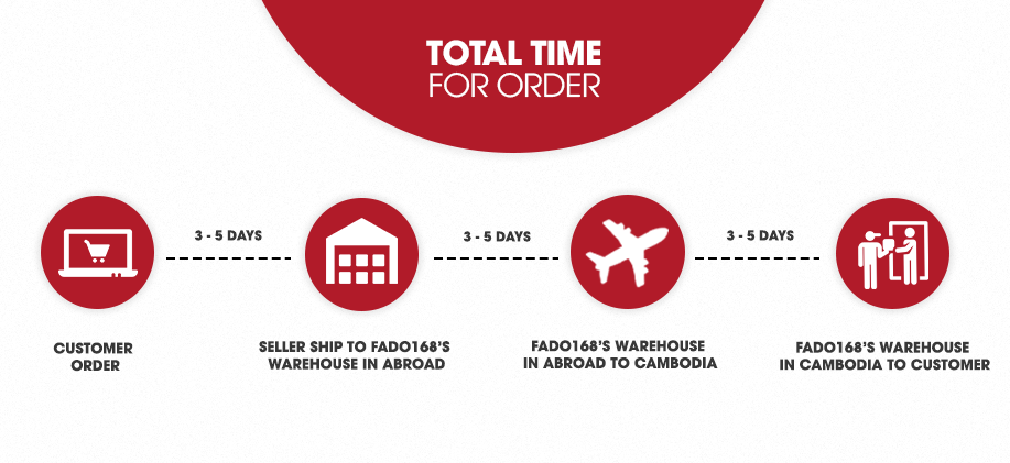
Fado168.com offers flexible shipping packages
3-5 days 7-20 days
+ See the detail
Free customs procedures
Fado168.com represent the customers to handle all the paperworks from the stage of export from ASIA import to Cambodia
+ See the detail
Diversified payment, flexible
Transfer by Internet Banking, via Bank account, by Wing or pay direct at Company
+ See the detail
Free delivery
Free delivery in Phnom Penh
+ See the detail
Safe shopping
With Fado168.com buyers always have insurance the risk when order the international goods
+ See the detail
Loading Product Infomation...


PRODUCT FEATURES
  • NOAA Certified: SMA26RTK is officially certified by NOAA and fully compatible with standard post-processing systems, ensuring reliable performance for precise geospatial data collection,CAD stakeout
  • 0.5cm Exceptional RTK Accuracy: Delivers 3mm–8mm accuracy when surveying with rover + base, based on real-world buyer feedback and extensive field testing
  • 10km Extended UHF Communication Range: Supports 5 km to 10 km UHF transmission between rover and base in open field conditions — ideal for large-scale agricultural, construction, and topographic applications
  • 【60° Advanced IMU Tilt Compensation】 Supports 30° to 60° tilt measurement with centimeter-level accuracy, allowing efficient data capture even when the receiver is tilted or on uneven ground 【Switchable Rover & Base】The SMA26 Rover and Base can easily be switched freely, allowing for seamless and flexible surveying in various field conditions. This capability reduces setup time and enhances workflow efficiency for both large-scale and small
  • 【High-performance hardware】32GB storage capability; Initialization time<5s ; 【10,000mAh Long-Lasting Battery】Features a powerful 10,000mAh battery, offering up to 2 full working days on a single charge — perfect for long field sessions without interruption
  • 【Wide Protocol Compatibility】 Capable of receiving signals compatible with CSS(Lora),Transparent, TT450S,Trimtalk, TRMMARK3, SOUTH, SATEL standard radio protocols. Also broadcasting signal compatible with CSS(Lora)protocol, ensuring compatibility with a wide range of base stations and GNSS ecosystems
  • 【Expert Support from Surveying Engineers】 Buyers can reach out to the SMAJAYU technical team via email for expert assistance, ensuring smooth setup and operation. A detailed PDF e-manual and instructional videos are also provided for self-guided support
  • 【Flexible File Format Support】 Import: .dat, .txt, .csv, .rw5, .raw, .kml, .kmz, .ncn, .pxy, .crd, .dxf, .shp, .dwg Export: .dat, .txt, .csv, .dxf, .dwg, .shp, .kml, .kmz, .gpx, .jpg, .html, .xls, .ncn, .pxy, .crd, .raw (saved in project)
  • 【Full-Frequency, Full-Constellation Support】 Compatible with global systems and built for extreme conditions. Adaptable for use in any country or challenging environment: GPS: L1C/A, L2P(Y), L2C, L5 GLONASS: G1, G2, G3 BeiDou (BDS): B1I, B2I, B3I, B1C, B2a, B2b* Galileo: E1, E5a, E5b, E6* QZSS: L1, L2, L5
Contact